

The seabed map will tell us more precisely about sea level as the ice melts and will help warn of impending tsunamis.
For experts in ocean mapping, it’s no small irony that we know more about the surface of the Moon and Mars than the seabed of our planet.
Great mystery
The ocean covers more than 70% of the earth’s surface but more than 80% of the ocean floor has not been mapped or explored, according to the United States National Oceanic and Atmospheric Administration (NOAA). “Can you imagine moving or doing anything on the field without a map?” – Mr. Larry Mayer, Center for Hydrological Nautical Charts (CCOM, US headquarters), raised the issue.
With many deep craters and mountain ranges, the vast ocean floor remains a mystery to humans. However, the situation could change if the United Nations (UN) -supported Seabed 2030 project succeeds. The project calls on countries and businesses to collect data to map the entire ocean floor by 2030. This map will then be shared free of charge to everyone.
“Obviously, we need a lot of cooperation from different people and organizations. We think this is an ambitious project but very achievable” – says Ms. Mao Hasebe, expert from the Nippon Foundation (Japan) . The project, implemented in 2017 above, is expected to cost around $ 3 billion, according to Reuters. This is a collaborative project between the Nippon Foundation and GEBCO – a non-profit association bringing together experts who have participated in ocean mapping.
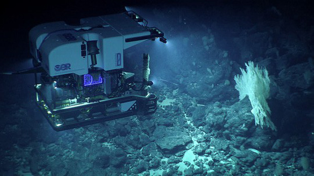
To date, the biggest data contributors to Seabed 2030 are companies – in particular Fugro Energy Exploration Company (Netherlands) and Ocean Infinity Mapping Company (United States). According to Mr. Mayer, the ocean mapping process was done a long time ago and Prince Monaco Albert I was the first to do it comprehensively in 1903. The rudimentary method used when he was forced to a block of lead at the end of the rope and drop into the water to measure the depth. After World War II, echo-reflection technology was applied, but the result was only a “blurry image”.
Today scientists can study the ocean floor more efficiently, in detail and much faster thanks to advanced technologies, such as hydropower, unmanned underwater vehicles, robots … ” With modern hydroelectric technology we can really see the seabed. I think we have escaped the age of blindness on the seabed “- said Robert Larter, marine geophysics expert at the British Antarctic Survey Center.
Efforts to explore Earth’s last frontiers, if successful, will have great scientific benefits, such as a better understanding of ocean biodiversity and climate. In a warming world, it will tell us more exactly about sea level as the ice melts and help issue warnings of impending tsunamis.
Equally important is the economic boost. According to statistics from the International Maritime Organization, over 90% of world trade is carried out by sea, so safe travel is a tremendous boost for the ocean mapping mission. “If the boat ran aground it was a bad day for the economy, for the environment and for the captain” – said Mr Mayer.
Geopolitical conflicts
According to experts, the seabed map is also useful in the context of countries and businesses seeking to protect or exploit marine resources, from oil and gas exploration to the installation of wind farms and fiber cables. Internet optics. The Organization for Economic Co-operation and Development considers that the maritime economy will play an increasingly important role in the years to come, and is expected to contribute approximately $ 3 trillion to the global economy here. 2030, compared to $ 1.5 trillion per year. 2010.
The 1982 United Nations Convention on the Law of the Sea (UNCLOS) allows states to define their continental shelf and exclusive economic zone. According to Larter, this sparked a race to map and claim land claims. Therefore, Mr. Julian Barbiere – a member of the Intergovernmental Oceanographic Committee (IOC) of the United Nations Educational, Scientific and Cultural Organization (UNESCO) – expressed concern after countries cooperated to share data to map the ocean floor, they can use their new knowledge to counteract each other in geopolitical conflicts
“There have been tensions in some parts of the world and this stems from various reasons, including access to resources” – said Mr. Barbiere. The expert further revealed that some countries are unwilling to share data for the Seabed 2030 project, mainly on national security issues or related to areas of geopolitical tension. “There is a lot of unpublished data. We hope we can change the perspective of countries and convince them to provide data,” Barbiere said.
Another major concern is that the race to exploit depleting resources, such as minerals or fish, is creating a new conflict over the ownership of underwater “treasures” whose total value is estimated at billions of dollars. Amid “mineral-hungry” countries seeking new sources of cobalt, copper and nickel to build infrastructure for a rapidly growing population, they will spend billions of dollars to develop and test public technologies to exploit d ‘immense resources at the bottom of the seabed.
Environmental activists warn that the increasing exploitation of marine resources carries many risks and can cause irreversible damage to the environment. According to experts, the ocean is a “neglected” area of global governance despite the advent of UNCLOS and the commitment of 193 member countries by 2015 to the protection and sustainable management of marine resources.